satellite imagery news
Latest from satellite imagery
North Korea appears close to completing its first airborne early warning aircraft
North Korea appears close to completing its first airborne early warning aircraft

Published on Mar 05, 2025 08:56 AM IST
AP |
Ecostani: Link between rise in wildfires and atmospheric convection
In the long term, wildfires interrupt terrestrial carbon uptake, potentially accelerating anthropogenic global warming.

Updated on Feb 24, 2025 03:26 PM IST
Chandigarh admn begins survey to identify encroached government lands
Deputy commissioner-cum-estate officer Vinay Pratap Singh said the Chandigarh has been utilising advanced technologies and satellite imagery in collaboration with revenue authorities to pinpoint illegal encroachments year by year

Updated on Jul 03, 2024 09:06 AM IST
HT Correspondent, Chandigarh
Ever-expanding Ghepan Ghat glacial lake poses flash flood threat
Long-term satellite imagery covering the Ghepan Ghat glacier in Himachal sets off a warning for glacial lake outburst flood. Satellite imageries reveal that the lake that was formed due to the melting of the Ghepan Ghat glacier in the tribal Lahaul and Spiti district has expanded majorly in the last 25 years.

Published on Jun 13, 2024 10:41 PM IST
Gaurav Bisht, Shimla
GDA to use satellite imagery to track unauthorised constructions
The images will help the authority to pin-point up to two to three feet of area besides helping to compare and track constructions going beyond sanctioned maps

Updated on May 04, 2024 05:34 AM IST
Peeyush Khandelwal, Ghaziabad
How does Ram Mandir look from space? ISRO satellite captures image
The ISRO satellite imagery unveils the partially constructed Ram temple, offering bird-view into the ongoing construction of the sacred structure.

Updated on Jan 23, 2024 07:22 AM IST
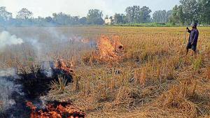
Satellite images show farm fires in Punjab and Haryana
Between September 15 and 18, Punjab recorded six fires, while Haryana recorded a farm fire each on September 15 and 16

Published on Sep 19, 2023 12:04 AM IST
HC appointed panel takes concrete steps for mangrove protection
The Konkan Divisional Commissioner has ordered immediate action on complaints regarding mangroves destruction, including installation of CCTV cameras and satellite imagery for protection. The committee also discussed issues like transfer of mangroves areas to the forest department and removal of debris. The High Court is already seized of the contempt petition filed by NGO Vanshakti, which claims that the mangroves have not been handed over to the forest department. Some remain cautious, stating that the committee has been passing directives with little action.

Updated on Sep 18, 2023 11:19 PM IST
China’s PLA scaling up in Aksai Chin: Satellite data
In light of Beijing's unveiling of the 2023 “standard map of China,” portraying Aksai Chin and Arunachal Pradesh as its territory, this development has emerged.

Updated on Aug 30, 2023 01:27 PM IST
Rezaul H Laskar, New Delhi
Haryana to use satellite imagery to monitor mining activities
The Haryana chief secretary said that CCTV cameras should be installed at locations designated for parking the impounded vehicles involved in illegal mining

Updated on Jul 01, 2023 12:59 AM IST
HT Correspondent, Chandigarh
EPCA writes to Punjab and Haryana to act against stubble burning
Delhi government data shows that in 2019, stubble burning accounted for 44% of air pollution in the national capital.

Updated on Sep 23, 2020 03:49 AM IST
Hindustan Times, New Delhi | Soumya Pillai
Satellite images show North Korea tried out rocket engine in ‘very important’ test: Experts
It was the latest of a series of weapons tests and statements from Pyongyang, as its year-end deadline for Washington to soften its stance in denuclearisation talks draws near.

Published on Dec 09, 2019 02:21 PM IST
Seoul | Reuters
Chandigarh gets a breather as air quality improves due to winds
The average AQI remained at 107 on Tuesday, just past the 100 mark, placing it in the moderate bracket

Updated on Nov 06, 2019 01:05 AM IST
Hindustan Times, Chandigarh | Rajanbir Singh, Chandigarh
Wildlife department to launch app to record sighting of wildlife species
The department will record sightings of each wildlife species in the district, and officials said the app will have details of each rescue operation, sighting, distribution of wildlife species and their movements.

Updated on Aug 09, 2019 08:07 AM IST
Gurugram | Leena Dhankhar
How a social justice tool became a means to grab land in India’s forests
Since Independence, waves of forest encroachments have been regularised on one pretext or another, and this unfortunate trend seems to be continuing. With a recent United Nations report warning that one million species of plants and animals are poised on the brink of extinction, we need to take all forest destruction very seriously

Updated on Jul 02, 2019 08:17 PM IST
Shekar Dattatri
The feminisation of Indian politics is an exciting phenomenon of our time
Women legislators in India raise economic performance in their constituencies by about 1.8 percentage points per year more than male legislators. When average growth is 7%, this implies that the growth premium associated with female legislators is about 25%

Updated on Jan 08, 2019 07:14 AM IST
Sonia Bhalotra
Supposed to give a boost to growth, scientific bodies face severe fund crunch
The department has been allocated an annual budget of ₹4 crore this fiscal. It is, however, only a marginal increase over the annual budget of ₹2.523 crore it was allocated last fiscal.

Updated on Jun 16, 2018 10:15 PM IST
Hindustan Times, Dehradun | Deep Joshi
Ayush ministry asks Isro for satellite help to gauge International Yoga Day ‘success’
The government now plans to make use of satellite imagery to get a sense of the number of participants in the events for the International Day of Yoga (IDY), to be held on June 21.

Updated on Jun 06, 2018 07:22 AM IST
Hindustan Times, New Delhi | Rhythma Kaul
Review: Legendary Maps From The Himalayan Club Edited by Harish Kapadia
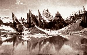
Elegantly produced, Legendary Maps from the Himalayan Club serves as a literary and visual atlas of Himalayan exploration

Updated on Apr 13, 2018 05:41 PM IST
Hindustan Times | Stephen Alter
North Korean nuclear site more active ahead of Kim Jong Un’s meetings
Satellite imagery taken last month suggests the North has begun preliminary testing of an experimental light water reactor and possibly brought another reactor online at its Yongbyon Nuclear Research Center.

Updated on Mar 29, 2018 11:36 AM IST
Associated Press, Tokyo | HT Correspondent


