MoEF modifies definition of high tide line to spare Goa’s khazan lands
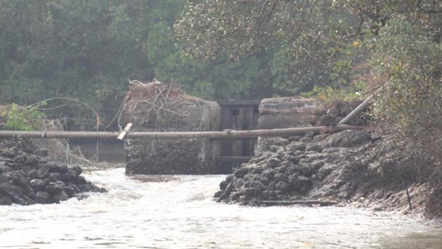
The High Tide Line (HTL) in Goa will now be demarcated along the bunds (embankments) along rivers and creeks even if such bunds have since been breached or lie in a state of disrepair.
The Union Ministry of Environment Forests and Climate Change has amended the Coastal Regulation Notification 2011 to ensure that the High Tide Line (HTL) in Goa will be demarcated along the bunds (embankments) along rivers and creeks even if such bunds have since been breached or lie in a state of disrepair.

The amendment came following a request by the Goa government.
Prior to this, the HTL was demarcated depending on how far landward the saline water travelled during the high tide, which in case of a breached bund meant the HTL was demarcated further landward having huge implications on which land is defined as Coastal Regulation Zone (CRZ).
In a notification issued on May 1, the MoEF has added a clause to section 2 of the CRZ 2011 notification to allow for situation where “there exists a bund or a sluice gate constructed in the past, prior to the date of notification issued vide S.O. 114(E) dated 19th February, 1991, the HTL shall be restricted up to the line long along the bund or the sluice gate.
“And in such a case, area under mangroves arising due to saline water ingress beyond the bund or sluice gate shall be classified as CRZ-IA irrespective of the extent of the area beyond the bund or sluice gate. Such areas under mangroves shall be protected and shall not be diverted for any developmental activities,” the amendment reads.
The amendment allows for an exception to be granted to the current rule which mandates that “the distance upto which development along tidal influenced water bodies is to be regulated shall be governed by the distance upto which the tidal effects are experienced which shall be determined based on salinity concentration of 5 parts per thousand (ppt) measured during the driest period of the year and distance upto which tidal effects are experienced shall be clearly identified and demarcated.”
The low lying lands known as ‘khazan lands, are protected from the high tides by a network of dykes and tide gates and have traditionally held multiple uses being used either as aquaculture ponds to breed fish and prawns in the monsoons, to plant rice during the winter growing season or to harvest salt in the summer, are now facing threats due to breaches in the dykes allowing for ingress of sea water as well as from reclamation for tourism purposes.
Goa’s khazan lands date back to 400 AD, when the earliest references are found in literature, to lands that were protected from the sea and tides through a network of bunds and sluice gates that controlled the flow of water and ensured that the lands were cultivable. The network is considered an engineering marvel.
According to government figures Goa boasts of 18,000 Ha. of khazans which is about 5% of the total geographical area of the state. Around 4,000 Ha. are estimated to have been lost over the last 30 years after they were inundated.
Goa has been lobbying for this change ever since the National Centre for Sustainable Coastal Management (NCSCM) which has been tasked by the state government for drawing up the coastal zone management plan insisted that in areas where there was ingress of saline water would have to be marked as ‘tidal influenced water bodies’ and lands up to 100m from the water line would be notified as Coastal Regulation Zone bringing fresh areas under the stringent CRZ regulations.
In August last year the Goa Environment Department wrote to the Ministry of Environment and Forests explaining the issue. The Coastal Zone Management Plan is a mandatory requirement under the CRZ notification. Goa is the last state to approve its Coastal Zone Management Plan under the CRZ notification 2011 which has been pending since 2014. An earlier draft plan placed before the government was rejected with the government telling the NCSCM that it could not be finalised owing to discrepancies.
The Coastal Management Plan will now have to be redrafted according to the new definitions.


