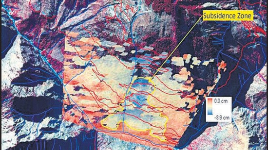
Joshimath sank by 5.4cm in just 13 days, says Isro report
This sinking, which NRSC described as “rapid subsidence” came on the back of “slow subsidence” of 8.9 cm between April and November 2022, which means that together, Joshimath has sunk by 14.3cm or almost half a foot since last April.
Dehradun:

In the span of 13 days between December 27 last year and January 8, Joshimath sank by 5.4 cm, according to a report from the Indian Space Research Organisation’s (Isro) National Remote Sensing Centre(NRSC), Hyderabad — data that indicates the gravity of the situation in the holy town in the Chamoli district of Uttarakhand.
That sinking, which NRSC described as “rapid subsidence” came on the back of “slow subsidence” of 8.9 cm between April and November 2022, which means that together, Joshimath has sunk by 14.3cm or almost half a foot since last April.
That could explain why cracks have emerged or widened in hundreds of buildings in the town, causing panic among residents, and pushing the administration to relocate the affected people even as it scrambles to find a solution to the problem.
NRSC’s 7-page report, which HT has seen, is based on Sentinel 1 SAR (synthetic aperture radar) satellite imagery using the DINSAR(differential SAR interferometry) technique. The method is used to observe phase changes between two images at a given time.
“Between 27th December 2022 and 8th January 2023 (possibly on 2nd January 2022 as per eyewitness reports) a rapid subsidence event was triggered. The region subsided around 5cm within a span of a few days and the extent of subsidence has also increased. But it is confined to the central part of Joshimath town”.
The report points out that the subsidence zone, in the central part of Joshimath town around Narsingh temple resembles a generic landslide in terms of shape, with a tapered top and fanned-out base, with crown of the subsidence located near Joshimath-Auli road at a height of 2180 metres.
A separate report released by Indian Institute of Remote Sensing, also affiliated to Isro, titled “Surface Deformation of Joshimath, Chamoli District, Uttarakhand Observed through Space-based Radar Interferometry” added that Joshimath witnessed a subsidence of up to 6.6cm between July 2020 and March 2022.
The report added: “Persistent Scatterer Interferometry (PSI) technique was used to estimate the land surface movement of Joshimath town for a period of July 2020 –March 2022…The results showed a significant subsidence rate in the Joshimath”.
YP Sundriyal, a geologist from HNB Garhwal University, Srinagar said the NRSC data shows an alarming trend. “The data shared by ISRO hints that there is a possibility that the rate of subsidence may further speed up, especially if there are rains in the area. Given the fresh data, the state government should expedite the shifting of the locals to safer locations at the earliest. The first priority of the government now should be to save the people of Joshimath , the town can be saved later.”
Hemant Dhyani, environmentalist and member of the Supreme Court-appointed High Powered Committee (HPC) on Char Dham Project, said the fresh data shows the subsidence of the Joshimath area in these times intervals. “But in the absence of long-term data on the subsidence of Joshimath, we have no idea about the general rate of subsidence and whether it has been increasing over the years and at what rate. If it is now rapidly increasing, the first thing government should do is to shift all locals to safer locations”.
The Isro report is consistent with reports by residents of the situation exacerbating in recent weeks, as seen in cracks in homes and fissures on the ground. Lakshmi Prasad, a resident of Manohar Bagh, who works at a hotel near Narsingh temple, said, “The cracks in my house started appearing around seven months ago but the situation escalated on the intervening night of January 2 and 3 when we felt the ground shaking as if an earthquake has hit the town.” He blamed NTPC’s tunelling work for a hydropower project for the immediate crisis.
RP Sati, who lives in the Upper Bazar area, said, “It’s been 14 months since when the first time the cracks in houses were reported in Sunil Ward. Since then, the situation is escalating with cracks getting wider. But, in the first week of January, cracks in houses deepened and big fissures started appearing in the ground”.
“Rapid sliding of surface can happen when there is subsurface lubrication or flow of water which suddenly accentuates the pace of sliding. But the source of water needs to be verified and causes ascertained through detailed investigation. Isro has datasets of satellite images to give the timeframe” said Kalachand Sain, Director, Wadia Institute of Himalayan Geology (WIHG).


