


Ignored red flags triggered flash floods in Sikkim
Multiple government agencies and scientific expeditions red-flagged the vulnerability of Lhonak Lake in North Sikkim to a glacial lake outburst flood.
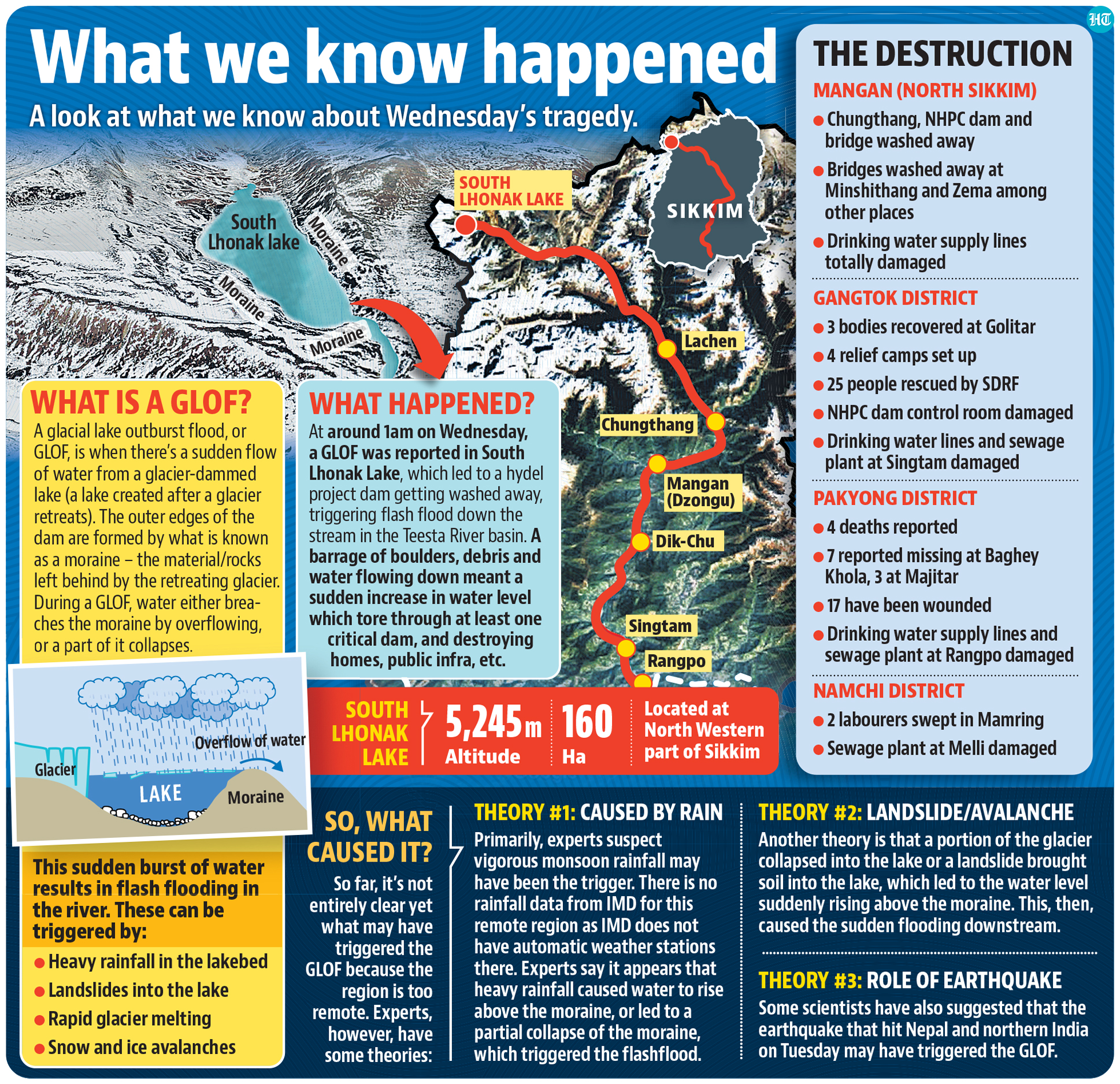
Multiple government agencies and scientific expeditions red-flagged the vulnerability of Lhonak Lake in North Sikkim to a glacial lake outburst flood (GLOF) for at least a last decade, documents accessed by HT show. On Wednesday, flash floods that originated from the lake coursed through the river Teesta, causing widespread damage downstream, destroying the 1,200 MW Teesta Urja dam, and leaving at least 11 dead and over 120 people missing.
")
Read here: Glacial lake outburst, excess rainfall led to Sikkim flash floods, says NDMA
A report compiled by the Sikkim State Disaster Management Authority (SSDMA) in 2019 notes that in 2013, scientists from the National Remote Sensing Centre in Hyderabad reported that the Lhonak Lake, at a height of 5,245 metres above sea level, was “highly vulnerable” to a GLOF event, which had the ability to cause extensive damage to life and property in downstream areas. It warned of the possibility of “flash floods” with important infrastructure such as dams and power houses susceptible to damage.
“Townships like Chungthang, Dikchu, Singtam, Rangpo are vulnerable. Loss of life and property likely,” it said.
That report mentioned that over the years, several field expeditions had studied the problem. The first such was in August 2014 by a team from the Snow and Avalanche Study Establishment (SASE) and Sikkim Department of Science and Technology and Climate Change and other stakeholders which reiterated the threat of “devastation” and asked for a mitigation management plan, and suggested “siphoning” as a short term measure.
Siphons are inverted pipes that are used to allow atmospheric pressure to force water from a reservoir over an embankment dam, then released from the other end of the pipe.
A second expedition to South Lhonak lake was carried out in September 2016, by a team from the Sikkim State Disaster Management Authority, the Indo-Tibetan Police Force, and the Students Education and Cultural Movement of Ladakh led by Sonam Wangchuk. That team found that “engineering intervention was not feasible” because of the threat of dead ice melting.
Wangchuk was appointed as consultant to implement the siphoning process, which included the installation of high-density polyethylene (HDPE) pipes in three pipelines,which were between 130 to 140 metres long, pumping out water at 150 litres per second. A monitor for water levels was also installed, the SSDMA report said.
“It was the first of its kind attempt – siphoning a glacial lake in India. A lake water monitoring system was also installed. The expedition came to an end in 2016,” a senior official of Sikkim’s science and technology department, said, asking not to be named.
Ashim Sattar, a scientist from Indian Institute of Science, Bengaluru, who has studied the glacier and the lake, said that in 2019, the area of the glacier was 12.5 square kilometres. “During the past 29 years, the glacier’s length has reduced from 6.4 sq km to 5.1 sq km, while the overall glacier shrank by 0.96 sq km. In line with the glacier retreat, the lake has been growing significantly over the years,” he said.
Sikkim has around 11 large glacial lakes, covering an area of 44 hectares, which are monitored by the Central Water Commission. Glacial lakes are dammed by unconsolidated glacial deposits that form unstable moraines.
With climate change taking its toll and glaciers retreating, there has been a corresponding acceleration of lakes at high altitudes, increasing the potential of a GLOF, officials said. “The Lhonak lake, which measured just 0.17 square kilometres in 1977, grew to 0.78 square kilometres in 2002 and 1.35 square kilometres in 2019,” said a senior official of the state disaster management department, asking not to be named.
Read here: Nepal earthquake or cloudburst? Scientists exploring cause of Sikkim floods
Sattar said that it was still early to understand the exact reasons behind the flash floods because dense clouds have thus far obscured satellite images. “But an avalanche, triggered by heavy rains, may have hit the lake. The impact likely triggered a GLOF and huge volumes of water and debris flowed down the Goma Channel,” Sattar said. The Goma channel joins the Zemu river, which further downstream, joins the Lachen, a tributary of the Teesta.
“As huge amounts of water and debris came rushing down, they hit the Teesta 3 dam near Chungthang. A major portion of the dam and the bridge connecting the power house have been washed away. With the breach in the dam, a flash flood was triggered,” a second senior official from the Sikkim disaster management authority said, also asking not to be named.

All Access.
One Subscription.
Get 360° coverage—from daily headlines
to 100 year archives.


HT App & Website
