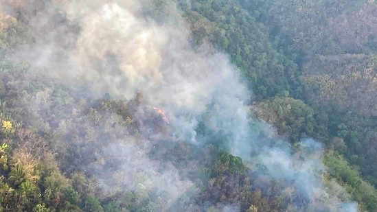
48 hours on, forest fires rage across Mizoram
According to a satellite data assessment by the Forest Survey of India (FSI), there were as many as 2,671 forest fire points in the state between April 20 and 26, with over 400 points on Monday alone.
Massive forest fires that broke out on Saturday and continued to rage till Monday have affected several parts of Mizoram and damaged vast tracts of land, satellite images have revealed. No human casualty has been reported so far.

According to a satellite data assessment by the Forest Survey of India (FSI), there were as many as 2,671 forest fire points in the state between April 20 and 26, with over 400 points on Monday alone. NASA’s Earthdata website also showed a very large concentration of fires in and around the state both on Sunday and Monday.
Speaking to chief minister Zoramthanga, Prime Minister Narendra Modi on Monday assured all possible assistance to deal with the situation. “Spoke to Mizoram CM, Mr Zoramthanga and took stock of the situation arising due to forest fires in parts of the state. Assured all possible support from the Centre in overcoming the crisis,” Modi tweeted.
The chief minister later thanked Modi and even tweeted a video of an Indian Air Force (IAF) chopper with bambi buckets (used for aerial firefighting), trying to douse the flames. “Thank you so much Prime Minister Shri @narendramodi ji. I thank the Central Government for its prompt assurance and swift action. The people of #Mizoram says ‘Kan lawm e,” Zoramthanga posted on Twitter.
The forest fire reportedly broke out at Saisih forest area in the outskirts of Lunglei town between 6 am and 7 am on Saturday and spread to Lunglei town on Sunday, Lunglei district deputy commissioner M Misael told news agency PTI.
While Lunglei is the worst affected, Serchhip, Lawngtlai and Hnahthial were also hit by the blaze as firemen deployed in several sites struggled to douse the flames.
According to the Indian Meteorological Department (IMD), the states of Mizoram and Tripura recorded “large deficiency” in rainfall during the pre-monsoon period from March 1 to April 26 at 74% and 67% below normal.
“There were over 400 forest fires today. Several factors may have led to this. They (forests) have large bamboo plantations and bamboo leaves are highly inflammable. When there is less moisture and high fuel load in the form of dry leaves and twigs on the forest floor, fire catches easily and spreads rapidly. Jhum cultivation is also another factor. Mizoram has very good forests. During this dry season, certain manmade factors may have led to extensive fires. But this needs to be ascertained on ground,” Sunil Chandra, deputy director (Forest Geoinformatics Division) of FSI, said.
Meanwhile, the weather body has predicted heat wave conditions over isolated pockets of Gujarat and coastal Odisha on Monday. A fresh feeble western disturbance is also likely to affect the Western Himalayan region from April 27, causing isolated rainfall/snowfall with thunderstorm and gusty winds over Jammu, Kashmir, Ladakh, Gilgit, Baltistan, Muzaffarabad, Himachal Pradesh and Uttarakhand between April 27 and 30.
A north-south trough (low pressure area) runs from Marathwada to south coastal Tamil Nadu across north interior Karnataka, Telangana and Rayalaseema in lower tropospheric levels, the IMD said. Under its influence, scattered to fairly widespread rainfall or thunderstorm is very likely over Kerala and Mahe, and isolated to scattered rainfall/thunderstorm over Maharashtra and remaining parts of south Peninsular India in the next three to four days. Heavy rainfall is also likely over north Kerala on April 28 and 29 and over south interior Karnataka on April 28 and 29.
Strong surface winds (speed reaching 20-30 kmph) are very likely over Punjab, Haryana, Chandigarh, Delhi and north Rajasthan on Monday and Tuesday.


